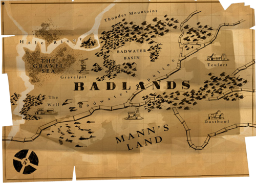
Map of Badlands
- This article is about the geographic Map of Badlands. For articles about the Badlands game maps, the Badlands Region, and other uses, see Badlands (disambiguation).
Map of Badlands or Map of Mann's Land refer to illustrated background content originally published in the Engineer Update page. Presented as a map taped to the brick wall behind Engineer's drafting bench, it revealed some of the in-game geography.
Contents
Badlands Geography
This map is taken to illustrate the geography of the in-game region called Badlands. It locates several facilities in that region that are represented by earlier Team Fortress 2 game maps. Some of the locations are marked by images of buildings from the relevant game maps. It is inferred that the map also locates settlements adjoining the facilities; for example, the town of Teufort.
Correspondence to Actual New Mexico Geography
This map has several features that correspond to features of central northwestern New Mexico, particularly the surroundings of the Española and Albuquerque Basins of the Rio Grande rift valley. The following table lists several points of correspondence.
| Map of Badlands | Map of New Mexico |
| Badwater Basin | Valles Caldera, having acid-sulfate hot springs, mud pots, and fumaroles. |
| Thunder Mountains, thunder references nuclear weapons; note the mushroom cloud on the map's promotion | Jemez Mountains, location of Los Alamos National Laboratory where the first nuclear weapons were made |
| Mountains between the two northwest branches of the Badwater Pipeline | San Juan Mountains, the Colorado-New Mexico mineral range, hard rock mining, gold, silver, lead, zinc, uranium, etc. |
| Mountains between Teufort and Dustbowl | Sangre de Cristo Mountains, the southernmost range of the Rocky Mountains |
| Mountains east of The Well | Sandia-Manzano Mountains |
| Mountains west of The Well | San Mateo Mountains |
| Dustbowl | Las Vegas, eastern New Mexico was the southwestern extent of the historic Dust Bowl |
| Pipeline | Sante Fe and close to where New Mexico Products Pipeline crosses the valley (see Notes) |
| The Well | Albuquerque |
| Teufort | Taos, the most agricultural area in the valley |
| Gravel Pit | Two large, red scoria gravel pits (over 50 acres each) are operating west of Sante Fe (see Notes). Two more very large gravel pits are northwest of Taos. |
| The Gravel Sea | San Juan Basin, extensive, unpopulated, barren, and gravely shale badlands (see Bisti Badlands). Pretty much nothing there except bluffs, hoodoos, and gravel; and the largest natural gas production and second-largest known uranium ore reserves in the U.S. |
| Lower main trunk and upper east branch of the Badwater Pipeline | Interstate 25 |
| Upper north branch and fork of the Badwater Pipeline | U.S. 84, U.S. 285, and U.S. 64. |
| Hale River
(This river provides the basis for including river navigation in maps) |
Obviously, there are no sea ports in this state, but the northeasterly bend of the Hale River recalls the San Juan River, which flows westward to the Grand Canyon. |
| Mann's Land
(An alternative name for this map) |
This area has little population compared to the Rio Grand valley, but there is some irrigated agriculture and ranching.
"No Man's Land" is a disputed territory or one over which there is legal disagreement. |
Correspondence with other U.S. States
There are some features of other U.S. States that are desirable for inclusion, but which are not particularly available in New Mexico.
Washington and Oregon
There are no ocean ports in New Mexico. If the navigation represented in Upwards is a depiction of the Hale River, then the point of placing the Hale River is to provide ocean shipping to the game maps. The Columbia and Snake rivers in Washington and Oregon carry hundreds of millions of bushels of wheat each year. The Hale River recalls these rivers:
- The navigable course of the Columbia River rises through forested mountains into near-dessert badlands.
- These badlands are irrigated to grow wheat, which is shipped off on the river. (see ocean vessel in Granary)
- Past these badlands, the Columbia and Snake rivers divide and each river rises up into higher mountains beyond.
- In places, bluffs and mountains exceeding thousands of feet overlook ocean-going vessels. (see ocean vessel in Upwards)
Colorado
Some mountains portrayed on the Thunder Mountain map are considerably higher than and very different in geology from those in the actual Jemez Mountains, which are more of a deeply erode high plateau than a range of uplifted mountain peaks.
- Colorado has 53 peaks exceeding 14,000 feet -- New Mexico has none.
- Colorado is replete with the type of hard rock mine operations depicted in Team Fortress 2.
- The proportions of the Map of Badlands are visually very similar to the map of Colorado.
Notes
- Built in 2003, the New Mexico Products Pipeline, a liquid refined petroleum products pipeline, passes southeast/northwest through the gap between Sante Fe and Albuquerque.
- "America's Gravel Basket" indeed: The main mineral resource mined in Sante Fe County is gravel. Some 80 of gravel pits have operated in that county. "Sand and Gravel is produced in the the largest volume and has the largest total value of (all) raw materials now mined or quarried in Sante Fe County." So, Sante Fe could in reality be called a gravel basket, but the map sets Pipeline in Sante Fe's place and it locates Gravel Pit further west.
- Sandia National Laboratories is also located in this region, south and southeast of Albuquerque, certainly a model for the in-game focus on missiles and atomic weapons.
